Introduction
1 Overview
2 Key technology of digital mapping
Part Ⅰ
Regional Geological Mapping System (RGMap)
1 Overview
1.1 System function
1.2 Operational environment
2 Program installation
2.1 Installation of mobile assistant program
2.2 Installation of digital mapping system
2.3 Installation of digital mapping dictionary
3 Preparation of field PRB map
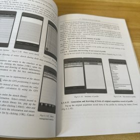
4 Collection of field path data
4.1 Open the program
4.2 Introduction of system shortcut buttons
4.3 GPS operation
4.3.1 Opening/closing GPS module
4.3.2 GPS manual acquisition of data and centered display
4.3.3 GPS automatic acquisition of data
4.3.4 GPS objective navigation
4.3.5 Setting of correction value of GPS error
4.4 Free-hand map operation
4.4.1 Opening of map
4.4.2 Saving of map
4.4.3 Closing of map
4.4.4 Management of layer
4.4.5 Resetting of map
4.4.6 System settings
4.4.7 Menu customization
4.4.8 Browsing of map parameters
4.4.9 Version of system
4.4.10 Quit from system
……


 直播中,去观看